Discover an impressive competition entry form the Italian architects Stefano Rocchetti & Luca Vernocchi. Proposal is titled "Cross-Cutting" shaped for the Dikemark location in Asker, Norway.

From the Architects:
Cross-cutting It is a terms of a cinematic technique: “Cutting between different sets of action that can be occurring simultaneously or at different times. Cross-cutting is used in movies to build suspense, or to show the relationship between the different sets of action”.
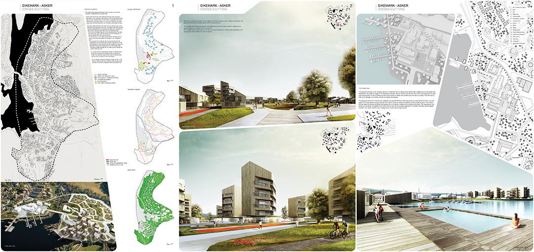
The principal characters of the natural and morphological landscape of Dikemark, are the lake Verkensvannet, Slottsberget the mountains, the river and the forest. This variety of landscapes and typological language has occurred through the establishment of the psychiatric hospital and its ancillary buildings. The former hospital not only determined the development of the area at the time of its operation but caused a decline in activity when the hospital ceased to operate. The natural features make Dikemark a place that has all the elements to be able to not only establish its own independence, but also to become a place of great interest with a strategic role in its surrounding region. The project area extends lengthways with the area of the former Hospital, reestablished as a central area. To the south the terrain of the hillside with large open spaces is dedicated to the cultivation and presence of some residential buildings and farm-related fields. To the north the vegetation becomes predominant and nature takes on a more ‘wild appearance with a large area of forest upwards to the mountains and along the lake. The main road divides the old town from the northern part of the area and continues along the north, southwest, east and centrally cutting longitudinally by a secondary driveway and ‘bordered on the south by the river which flows into the Verkensvannet. One of the immediate features is the fragmentation of this area into three main areas with the historical centre working as attractor between the north and the south. The center has its own identity which dates from the years of activity’ and the organization of buildings to an orthogonal grid. This arrangement contrasts with the agricultural and wild landscape in the south and the wild and mountainous north. The presence of the road and the river isolates this area from the rest of the site as a statement of its own identity. The motorway divides the site into two parts, going through the central historical zone. Our project aims to maintain the identity of both the landscape and the historical heritage. It also proposes to create links between areas which relate to different time periods and moments of life of the people. As a cinematic sequence between single frames, in the project, different elements create a unique place where the past of the site is preserved with a purpose for future continuation. The development of residential, commercial and recreation stem from this idea.
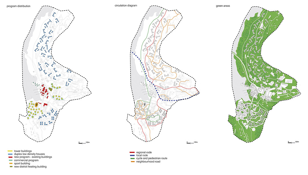
We have identified four different moments, or ‘scenes’. The former hospital buildings are to be the heart of the community, standing as a representative area for social and recreational life of the town. Public, administrative and commercial buildings will provide this. The south side of the area will be occupied by residential buildings consisting of two main typologies which are apartment buildings and single family homes. These two types are designated for different user groups: Elderly, single family, holiday, second homes, young people and social housing. Although the two residential areas and the central area physically appear with differing identities, they are connected in the public external space through cycle and pedestrian routes. The subdivision in the areas are aimed to create stronger links to one another through their balance of purpose in the overall masterplan. The pedestrian and cycle routes create links through all the areas and is routed along the lake. The north area will consist of existing single family homes and new single family homes that utilize the lake view, located within the green hillside landscape. Two iconic buildings are located on two key points in the overall development. On the southside, between the centre and the new residential area, we established a multisport complex. On the north side, a thermal energy building is located in the open area between the central zone and the hillside.
In the current situation, the residential and commercial buildings of Dikemark can be quantified in 80,000sqm, 55,000sqm of which belongs to the former hospital buildings. The proposed strategy for the residential and commercial developments will be an 58,200sqm of mixed use space to the area, 2,250sqm for the sports complex, 1,700sqm at the new district heating building and 14,800sqm for commercial use. This gives a total of 77,000sqm of total new development area. We deliberately decide not to achieve the target as proposed in the brief, in order to avoid overpopulating the area. The strategy is to include pedestrian and green areas to add to the development in maintaining a balance to built-up area and open space. The schemes that are proposed, build on the idea that future growth is possible with the proposed typology and footprint of the buildings with its ancillary open spaces and urban connections.
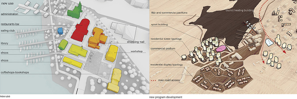
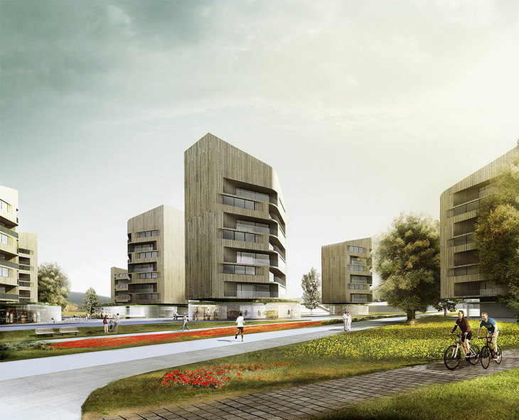
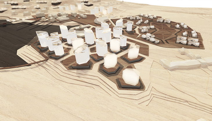
the main residential area is developed at the south side of the original hospital location and is connected with this as a natural extension of it. This new area consist of ten buildings with a variable height that goes from 4 to 8 storey. The main construction material of the buildings is local timber. As per the exterior cladding also the structures are made with local wood that guarantees excellent mechanical properties sustainable characteristics and cost reduction due its diffusion in the local area. the construction strategy based on local contractor and local material doesn’t come just form the design strategy but it is also a fundamental element to take in consideration in order to stimulate the local economy that experientially in our case, is essential. This approach is the first step toward a sustainable design that means not just renewable resources but also use of efficient technology and optimization of the construction process with waste reduction, starting from the material transportation cost and the emission on the local market of the capital spent, utilization of local material etc… The design approach has a main rule in the sustainable strategy. A smart design can allow to optimized the design geometry in a way of saving unnecessary waste and achieve the concept aim anyway. the foot print of the buildings is hexagonal in order optimize both the lighting of interior spaces than the views towards the lake, also the orientation of the buildings has been designed to avoid overlooking conditions and the protection of privacy. The mountain is one of the elements of the landscape with the greatest impact on the territory, the necessity of create residential density adequate to the new needs that Dikemark is going to have and then create to achieve that aim tower buildings, gave us the chance to use the mountain as inspiring element . The towers have a module AB repeated all the time that disappear into the overall vision. The roof is very steep and sharp facets of the sides, the towers change in height moving away from the shore of the lake. The rotations and the staggered positioning determines a skyline extremely varied that want ot be a visual reference of the mountain to Slottsberget north of Dikemark. each building serves apartments of varying size, also to encourage the employment of different types of tenants within the same building. with sizes ranging from 60 to 150 square meters. the tower lay on top small podiums with commercial recreational activities that overlooks through large windows the surrounding streets, the halls have a different footprint of the towers. The footprint derives directly from the organic urban subdivision and enables users to experience more dynamic and exiting space and variation op spaces walking next or into them. The irregular footprint of the pavilions/podiums below the towers let part of the roof sticking out and showing itself looking from the apartments. That roof portions are cover by vegetation in order to partially replace the green removed with the construction and maintain the appearance of green continuity that is characteristic of the area. the towers are grouped by clusters of three or sometimes two. Each cluster has a park dedicated to the towers.

the low-density residences have the same design strategy of the towers, with use of local wood and local materials. Each block has two apartment of 75 sqm, one per floor, with common access. The group of houses located on the south part of the site area have a urban organization designed to enhance the social aspect of the community life. With the deviation of the driveway path on the outside of the residential areas we e had the chance to create a courtyard park bounded by residences that close that area up with access from the park and from the external driveway where are also located the parking spots The residences of that area are grouped together in groups of two in order to optimize the space thanks to a modular scheme adopted. The central park has an organic and natural shape enclosed in a more sharp pedestrian and bicycle path with facilities for open-air sports. We believe that this typology is the best for this kind of area and offers a very high of life. The residences located on the north side of the site area have a more independent identity. They are not liked between each other. The distribution on the territory is punctual but still defined by small groups or clusters. This choice derive directly form the typology of the landscape and natural scape that define a kind o dwelling more “solitary and quiet” rather that social and interactive where you can have a different type of life an experience.
The original buildings of the Hospital campus in Dikemark form a natural local centre with a relationship to the green hills beyond and the water frontage of the Verkensvannet lake. Where currently divided into five zones, the proposal is to physically and socially link the buildings and its surroundings to create one central area that forms an urban hub with strong links to its heritage, community culture and natural landscape. The proposal stems from the need to celebrate the specific identity of the community by promoting the history and heritage of the place whilst looking towards the future to create an urban framework for that identity to grow. This is done through reuse of existing buildings and spaces for commercial, cultural and recreational facilities. The regeneration will promote a multitude of qualities to the area that will not only encourage migration to Dikemark, but also attract regular visitation from Asker and the surrounding areas, tourists and foreign visitors. At the heart of the centre, additional commercial functions aim to promote local products and create opportunities for new local businesses to grow. Specialist shops with particular offers and distinct produce will form uniqueness to the area, giving it a regional role. The waterfront will form a second attraction to the town with sport, leisure and recreation for families, seasonal events and stopovers for visitors by boat. Through understanding the local architecture and spatial planning of the centre, there will be an adaptation of the existing listed buildings to house new functions that compliment each other and work as one unique entity. The architecture of the buildings are such that internally they contain a combination of open plan spaces with high ceilings and controlled natural lighting, as well as cellular spaces to house more private use. This distinct typology can be utilized not only as restaurants, cafés, shops and markets but more particular functions such as a library with a community centre in the former administration building and a regional museum within the workshop building.

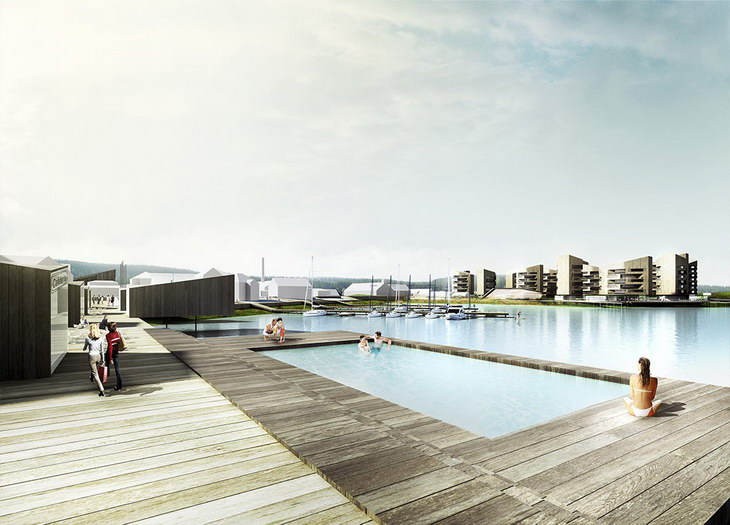
Externally, the location and footprint of the buildings have allowed for vast open surrounding spaces, with room for expansion for future development. This is used to define different types of public spaces that create an urban quality to the area through streetscapes, a waterfront promenade, urban squares and a new marina and pier. Two main squares are established within the geometry of the existing buildings. The first is a more urban square which relates to everyday urban life where cafes, restaurants and shops spill out to the open space. The second square is situated adjacent to the marina and forms a connection between the central area and the lake. This functions as a more adaptable public space for temporary or seasonal events, festivities and celebrations. In bringing the central area closer towards the lake, a new promenade links the main areas of the town to a marina and waterfront pier. The pier is populated with commercial based pavilions and a public swimming pool, catering for families and holidaymakers. A sailing club provides sporting and leisure activities, giving the town a second identity for being a waterfront hub. This myriad of new functions is essential to establishing Dikemark as an urban centre with a strong presence and opportunity for further growth. An established heart to the overall masterplan will support the surrounding residential areas, workplaces and social infrastructure.
Project: Cross-Cutting
Designed by Stefano Rocchetti & Luca Vernocchi
Location: Dikemark, Asker, Norway
Website: www.stefanorocchetti.it


